Weather Summary
A series of fronts will bring valley rain, mountain snow, and gusty winds to southern Oregon and northern California. The first front will arrive on Wednesday, the second and wettest front will arrive on Thanksgiving and linger through Friday. The last of the fronts will arrive Friday night into Saturday. Precipitation will gradually end on Saturday evening into Sunday. Temperatures will be relatively colder after Sunday, with lows reaching the low 20s east of the Cascades and the low 30s west of the Cascades, except for the coast.

Series of Systems to Bring Valley Rain, Mountain Snow, and Gusty Winds to Southern Oregon and Northern California
Impacts
· Gusty winds at the Coast and Shasta Valley and strong winds east of the Cascades will make travel difficult, especially for high profile vehicles.
· An increased risk for accidents due to high traffic volume and the first moderate to heavy rainfall in nearly a month.
· Moderate to heavy rain could create the potential for isolated debris flows for burn scars in Western Siskiyou County and in the Coast Range.
· Snow and icy roads will be expected for the higher passes (Diamond Lake, Lake of the Woods) creating an increased risk for accidents during holiday travel.
Forecast Confidence
· Winds: High, except medium for Rogue Valley.
· Rain amounts: Medium confidence that we will see significant rainfall in the Mt. Shasta area on Wednesday night, and medium to high confidence that we will significant rain at the Coast and Coast range on Thanksgiving. Low to medium confidence for rain amounts elsewhere.
· Snow Levels: High confidence that the higher passes (Diamond Lake, Lake of the Woods) will see snow. Low confidence that Siskiyou Summit on I-5 will be affected. High confidence that low passes (Canyon Creek, Sexton Summit) will not see snow.
· Snow accumulation: Low to Medium
Timing and Strength
Rain:
Rain will occur beginning on Wednesdaybecoming showery on Wednesday evening.
Another system will arrive Thursday bringing heavier rain to southern Oregon, especially at the Coast and Coast Range.
Rain will linger into Friday and Saturday, with the best chance for additional heavy rain over northern California. Rain will begin to decrease in coverage and intensity.
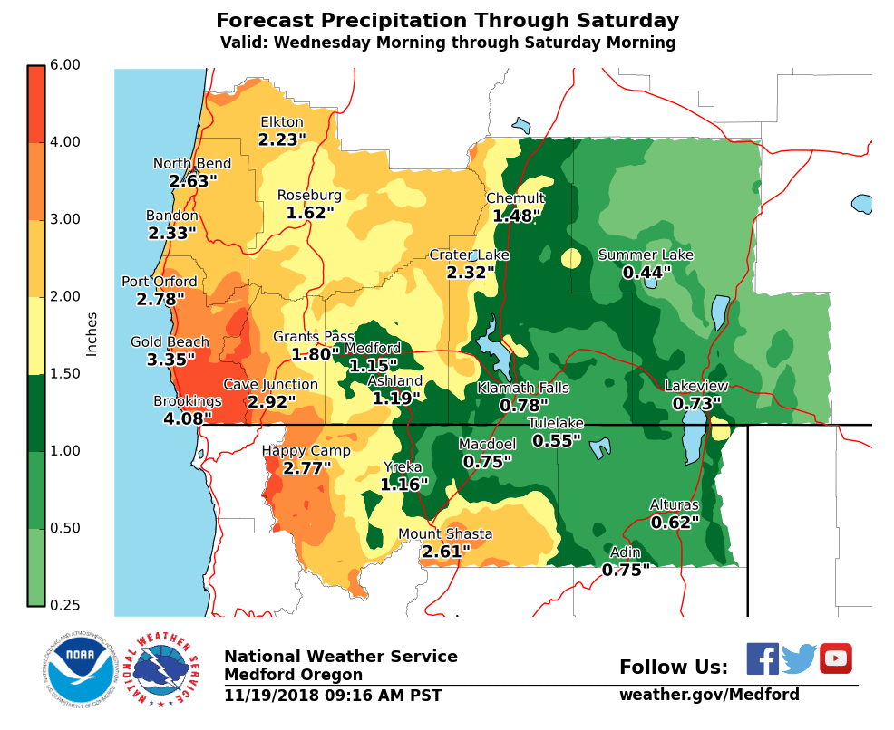
See attached rainfall graphic for specific amounts.
· Snow:
Snow is expected at the higher passes, including Highway 140 at Lake of the Woods, Diamond Lake, and Crater Lake. This does not include Siskiyou Summit on I-5.
Snow levels will start at 6000 feet and drop to about 5500 feet on Wednesday. Snow levels will begin to lower on Thursday, but will stay above 4500 feet.
Snow levels could be lowest on Friday into Saturday morning, still above 4500 feet west of the Cascades and around 4000 feet east of the Cascades.
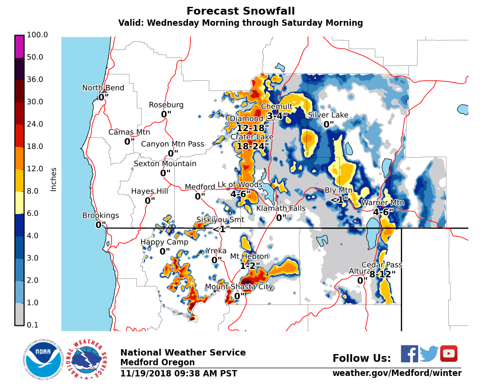
See attached snowfall graphic for specific amounts.
· Wind:
South winds will increase ahead of the first front on Tuesday, and will be strongest for the Shasta Valley.
Gusty winds possible in the south end of the Rogue Valley near Ashland Tuesday nightinto Wednesday. Gusty winds are expected east of the Cascades Wednesday.
Gusty winds expected at the coast and Shasta Valley on Thursday morning, and will spread to areas east of the Cascades by Thursday afternoon. The strongest winds will be near Summer Lake.
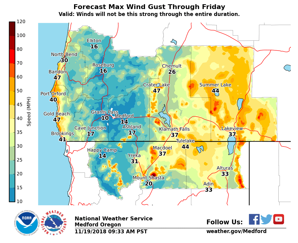
See attached wind graphic for specific amounts.

For a detailed view of the hazards areas and observations, visit the NWS Weather and Hazards Viewer.
Monitor NWS Medford on the web FacebookTwitter and YouTube for further updates.