

Klamath Alerts Weather Outlook – Strong Storm Expected Monday
Posted 1-2-22 (AM Update)
For additional weather information and briefings subscribe to our breaking news app.
A strong storm with high winds is expected to begin impacting the Pacific Northwest as soon as Sunday afternoon. The majority of precipitation is expected Monday into Thursday. Hurricane force wind gusts are possible along the coast and in the higher elevations of Klamath and Lake Counties. Blizzard conditions will be possible in areas exposed to winds during heavy snow showers. Snow rates that exceed 1 inch an hour are possible in the Cascades. Due to the wet and heavy nature of the snow and high winds, power outages will also be possible. Increasing snow levels and warming by Tuesday could cause some minor flooding concerns (near the coast mostly).

A series of atmospheric rivers will move into the region next week. Multiple waves of moisture are possible Sunday afternoon through Thursday. Snow levels will begin low Sunday evening, but will rise through Monday and Tuesday. Heavy rain and melting snow could lead to quick rises on area streams and rivers, with minor flooding possible in some locations.
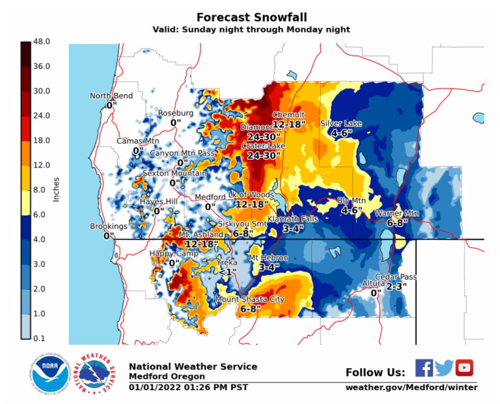
- Heavy precipitation is expected to begin along the coast by Sunday evening, then spread inland through Monday. Snow levels begin at around 2000 feet Sunday evening, but rise to around 4000 feet by Monday evening, and around 5000 feet by Tuesday afternoon. Heavy snow is expected in the Cascades, Siskiyous, and the Mount Shasta area beginning Sunday night. Several inches of new snow is possible for these areas, including the mountain passes.
- Strong winds are expected along the coast, in the Shasta Valley, over higher terrain, and across the East Side Sunday afternoon through Monday afternoon.
- Wind and snow may combine to create periods of limited visibility and blowing snow, particularly on the East Side and possibly the Shasta Valley
- Heavy rain on saturated soils, along with melting snow, could lead to flooding concerns west of the Cascades. Quick rises are expected for smaller creeks and streams.
- South, storm force winds as well as heavy rains and King Tides could combine to produce localized minor coastal flooding.
- For the local Klamath Falls area, about 3-4 inches of snow are expected Monday and Tuesday before snow levels rise and precipitation changes to rain by Tuesday afternoon. Windy conditions are expected to begin developing by Sunday afternoon locally.


